Friday, 5 June 2015

Week 9

LECTURE

Today's lecture spoke about how digital media such as advertising on building facades could be changed to bring back the qualities of the architectural facade with less obtrusive technologies.

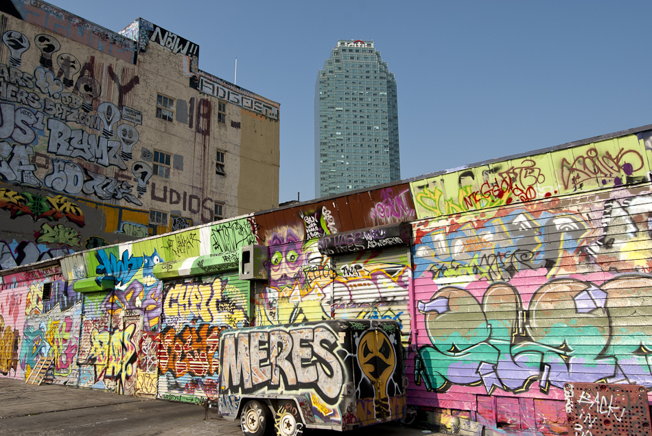
Examples of over use of digital media are evident in New York which becomes intrusive. 

http://www.iro.kz/_bd/57/5776.jpg

Less obtrusive ways of advertising information were discussed such as an intuitive system which would display the weather conditions through color on a building facade, or using model crickets to display information acoustically through cricket chirping.

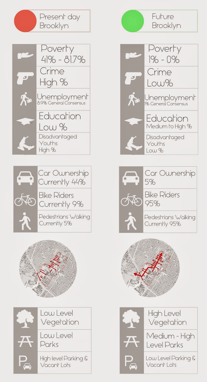
Like with last weeks example for potential technology designs for my building, information based on my site mapping could be displayed through color where progression through a mapping condition from present conditions to future conditions could slowly change color.  This is shown in present and future conditions in the below graphic where red is present and future is green.


------------------------------------------------------------------------------------------------------------

TUTORIAL

During tutorial time we had a group discussion about the use of space, and how space could serve multiple purposes.  This made sense to me not only in the short term of the building, where current activities could be undertaken multiple ways, but also in a future sense where previous activities were not required, but the space could be adapted for new uses.  This aspect of multipurpose space is also what could be the difference between a great mark, or marginal pass.

Below is but one example of multi purpose space depending on the programming, with multiple purposes seen such as a cafeteria, indoor sports such as a basketball court and presentation stand.


Multi Purpose Space
http://www.designshare.com/dbadmin/upload/projects/1/517/multi-purpose%2001.jpg

we undertook a workshop which consisted of testing different materials for architectural model making which was quite interesting.  For a student who uses balsa wood and white card in the majority of his models, i could see the benefits of expanding my material pallet, which could improve time spent on models as well as the textural quality and color.

Model Making Tools and Materials
http://www.dsource.in/gallery/gallery-0035/fullview_image/1.jpg

------------------------------------------------------------------------------------------------------------
HOME TIME

During home time i continued on site planning and positioning of my design intervention taking into consideration my primary mapping analysis of gentrification and my secondary mappings, revitalization and connection.

I also started on the curated journal aspect of the submission to avoid putting the journal together quickly and without thought.


Sample pages from curated journal

------------------------------------------------------------------------------------------------------------
Site Contours


Contour Map

Information sourced from
Viewer.Nationalmap.gov

The chosen site has a 3 meter elevation from Smith Street to the Gowanus Canal edge giving the site a gentle slope of grade 1/70


Birds Eye of Land Elevation

Section of Land Elevation


----------------------------------------------------------------------------------------------------------------------------------
Site Conditions

Site Conditions Analysis

The site is put under summer and winter weather conditions, with winter prevailing winds coming from the west north/west and summer prevailing winds coming from the south.  

The site has full access to both summer and winter azimuth as existing buildings do not interrupt the suns path.

Both these conditions will be used for passive design techniques such as natural ventilation and passive solar heating as recommended by the psychrometric chart in ecotect weather tools.

Passive Design Analysis

------------------------------------------------------------------------------------------------------------
Urban Field Station Analysis/mapping


Bubble Map

Doing these quick analysis it became apparent to me that there could be distinct zones within the Urban Field Station.

3 zones i have identified:

3 Zones Map

Zone 1: 2400m2
Lobby/reception, Auditorium and Exhibition Space.  The Auditorium and Exhibition spaces are some of the larger spaces coming in at 1250m2 and 1000m2 whilst the Lobby/Reception is relatively small at 150m2 which connects these two spaces in a formal manner.  These areas will be the first areas seen as visitors proceed into the space


Zone 2: 2000m2
Work Space 500m2, Academic Space 1000m2 and Gowanus Resources 500m2.  These spaces branch off from zone 1 acting as secondary spaces.  (for example material produced in the work and academic spaces can be showcased in the exhibition space.)  These areas will be seen after the visitors have entered into the design intervention which will most likely be located on proceeding floor levels.

Zone 3: 250m2
Recreation Space 250m2.  The recreation space is a continuation of the auditorium which is planned to be used for multiple purposes such as lectures and indoors sporting evens such as basketball and netball.


The design of the buildings in assignment 1 focused on courtyard style spaces/shared backyards which were evident in many Brownstone city blocks in Brooklyn.


Brownstone Courtyard/Backyard
Red = Building
Green = Courtyard/Backyard


The idea behind this is for people not to be locked away in respective parts of the building but rather be visible to other occupants to give a sense of closeness instead of segregation.

This idea will follow through for assignment 2 but at a smaller scale.


Tuesday, 28 April 2015

Week 8

LECTURE 

The lecture today spoke about digital facades and their uses in environments portraying types of media such as social expression, interaction and advertisement.

Examples below showcase how lighting is used on facades to display patterns, images and messages from public and private entities. 


Digital Facade 1
https://gjamesau.files.wordpress.com/2012/09/4343393904_0b0857951b_b.jpg?w=662&h=442

Digital Facade 2
http://media.cmgdigital.com/shared/img/photos/2012/08/12/9e/56/slideshow_1002161503_AJC02.jpg

Digital Facade 3
http://i.guim.co.uk/static/w-620/h--/q-95/sys-images/Guardian/Pix/pictures/2014/2/7/1391782909178/15a3d804-13ad-4471-b251-3bee6a4ceacc-620x372.jpeg

The Cube P Block QUT Gardens Point
https://c2.staticflickr.com/8/7282/8737913738_b6943d277f.jpg

------------------------------------------------------------------------------------------------------------
TUTORIAL & HOME TIME

Reflecting upon assignment 1 and the lecture which had just passed,  i failed to embrace growing trends in social technology such as social expression and interaction.

Having thoughts heard from the effects of Gentrification, such as the constant struggles of daily life including unemployment and poverty could be a powerful tool.  These thoughts could be beamed or digitally scrolled across the proposed buildings facade.

Mapping analysis from assignment one is one example of information which could be shown on the buildings facade showing current and future projections, as well as peoples thoughts as they transition from lives of poverty to lives of virtue.

Assignment 1: Mapping Analysis icons

------------------------------------------------------------------------------------------------------------

Example buildings which display messages of community changes are present in Gowanus such as the BRT Powerhouse as messages are painted on the top of the buildings brick facades.

BRT Powerhouse Written Message 1
http://bridginggowanus.com/wp-content/uploads/2014/11/Powerhouse-cropped.jpg

BRT Powerhouse Written Message 2
http://powerhouseworkshop.org/wordpress_561337030/wp-content/uploads/2014/03/west-face-9-13.jpg

------------------------------------------------------------------------------------------------------------
Reducing sites from 3 to either 2 or 1 sites by utilising SWOT Analysis


http://www.parkhurst-consulting.com/wp-content/uploads/2014/03/SWOT-Analysis-CMYK.jpg


Site 1
Strengths
-Close to public transport.
-Large site.
-Close to mapped study areas.
-Close to canal for water access
-Close to planned pedestrian and bike paths.
-Close location to commercial activity.
-Close to site 2.
-High level street presence.
-Passive design techniques as site is open and sun is not blocked out by surrounding buildings.
-Site accessible from 2 sides.
Weaknesses
-Site lacks place making and landmark identification for long term residents.
-No reusable architecture that relates to long term community or culture.

Opportunities
 -Create a connection between disadvantaged communities and the commercial sector.
-Site could work in conjunction with site two through intervention connection (site buildings could be spread out instead of 1 or 2 larger forms)
-Opportunities for site beatification.


Threats
-Flooding issues.
-Current state of canal (off-putting odours) could slow initial site progress until canal is clean.


Site 2
Strengths
-Close to mapped site conditions.
-Close to commercial district.
-Close to site 1.
-Close to canal for water access.
Weaknesses
 -Little public transport connections
-No place making or landmark through lack of existing architecture.
-Limited street presence.
-Potential crime hotspot as site is not located on main thoroughfare.
-No reusable architecture that relates to long term community or culture.

Opportunities
-Create a connection between disadvantaged communities and the commercial sector.
-Site could work in conjunction with site one through intervention connection (site buildings could be spread out instead of 1 or 2 larger forms).
-Opportunities for site beautification.
Threats
-Flooding
-Current state of canal (off-putting odours) could slow initial site progress until canal is clean.
-Canal dead end located near site could increase already distinctive bad smell of canal.


Site 3
Strengths
-Close to mapped site conditions
-Site has historical significance
-Architecture can relate to long-time residents
-Place making attributes.
-Current architecture has unobstructed views of Manhattan.
-Site access to canal.
-Site close to existing bridges so residents on both sides of canal can gain access.

Weaknesses
-Site previously used as a drugs/crime hotspot
-Site not close to sites 1 and 2 for potential connections. (Used as singular)
-Limited site presence because of Storage      Deluxe Building.
-Limited site access through lack of pedestrian paths and street access
Opportunities
-site could promote Brooklyn’s art scene providing means to showcase artworks.
-Opportunities for site restoration.
-Treating the site as one art work in progress.
-Site beautification.
Threats
-Flooding
-Current state of canal (off-putting odours) could slow initial site progress until canal is clean.
-Repeat of crime in future settings


Summary:

Moving from 3 sites to either 2 or 1 sites based upon the SWOT analysis came up with the following conditions in brief

Sites 1 and 2:

-Sites 1 and 2 are highly connected to Gowanus surrounding context as well as being highly connected to each other which is described in assignment 1.  The potential to spread the urban field station over 2 sites into components as identified in assignment 1 is also to be considered, although this would mean the doubling up of some building services such as administration and toilet facilities.

Site 3:

-Site 3 is also highly connected and can be accessed from both sides of the canal through existing bridge infrastructure.  The site is not as well connected to the other two sites as it is not in close proximity although the planned canal pathway would connect these sites.


Site Proposal:
Based upon SWOT analysis, site 1 in terms of connectivity and proximity to mapping conditions was chosen.

Assignment 1: Site 1

------------------------------------------------------------------------------------------------------------


Thursday, 16 April 2015

Week 7: Part 2

Presentation Reflection

Final thoughts

Personally, i struggle with presentations as i can never seem to get my point across (Whats in my head does not translate through speech...)  Regardless i think i still got valuable feedback about how i could further connect the site thinking about the broader context rather then just focusing on particular areas such as segregated demographics.

Splitting the field station component into 3 separate areas could also cause issues with the doubling up of resources such as admins, sanitation facilities and eating facilities to name a few.  I feel that my Educational facility had a stronger connection to site mapping and conditions compared to the recreational, arts and culture facilities.

Presentations

The presentations that i found the most interesting were firstly, the use of social media to detect hotspots, and use that information to reuse historical buildings for new activities. 

http://www.graphicsfuel.com/wp-content/uploads/2013/03/20-social-media-icons.png

Secondly the predicted water rise from global warming over a 100 year plus time period, and how the sites and interventions would adapt to this change.

http://static.neatorama.com/images/uploads/2007/01/manhattan_global_warmingjpg.jpg

Wednesday, 15 April 2015

Week 7: Part 1

This week i finished up on the finer details to bring the 2 A1 posters together ready for submission

Perspective View of Educational Institute


2x A1 Panels


Rough Massing Model of Sites


Instead of having a dozen maps on my panels, i decided to summarize my maps down into simple icons which supported my 3 main maps, Gentrification, Connectivity and Revitalization. 


Week 6: Part 2

Once sites were chosen i began to draw up a master plan focusing on the 3 sites
------------------------------------------------------------------------------------------------------------
Climatic Data


For cooling in the summer periods, prevailing winds come from the south.  In conjunction with the psychometric chart, accessing prevailing winds will aid in the natural ventilation process of the intervention which is recommended.  

Winter winds will be avoided as Brooklyn experiences very cold winters with passive design techniques used instead.  Optimum orientation to access the southerly sun in winter is South East orientation with 40% plus glazing on the southern facade with materials with high thermal mass properties.  Prevailing Winds can be avoided by planting vegetation along the western facades.

Information sourced from Ecotect Analysis, Weather Tools.

------------------------------------------------------------------------------------------------------------


Educational Institute Site Mapping


Rough Massing Sketches for Building Mass

For the building masses i had a few concepts in mind which are taken from Brooklyn's architecture.  Firstly the use of arches in windows such as the window arches in the BRT Powerhouse.

 
http://www.6tocelebrate.org/wp-content/uploads/2013/12/brt-powerhouse-4.jpg

The building form will be close to the street scape whilst having an internal courtyard.  This is similar to many of the Row houses in Brooklyn which are commonly refereed to as brownstone homes.


http://upload.wikimedia.org/wikipedia/commons/3/34/Bedstuybrownstone1.jpg

 googlemaps.com.au

The building form will also incorporate modern elements which take into account site conditions such as the southern sun and prevailing winds.  louver systems fixed to curtain walls will control the amount of light that penetrates and the prevailing winds which can enter.

http://zwhcherry916.en.ecplaza.net/17.jpg


'http://image.made-in-china.com/4f0j00TCaQBYGPRcbW/Aluminum-Aerofoil-Architectural-Sun-Louvers-for-Curtain-Wall-with-Fixed-or-Motorized-System.jpg

The final concept would be to imagine what the building could look like in the future whilst having remnants
  of the past of past architectural styles. 

These concept forms will carry over onto the 3 building zones.  Educational, recreational and Arts and Culture.


Educational Institute 


Culture and Arts institute, BRT Building on the left, extension on the right.


Recreational Institute.

------------------------------------------------------------------------------------------------------------

How to proposed buildings react to mapping analysis?

Education Center Purpose

The center reacts to a number of conditions as a result of gentrification and aims to improve these conditions through improved education initiatives.

Firstly, segregated communities which have been selected as a result of gentrification show that there are high levels of unemployment, low income levels and low levels of attained education.


http://www.homefacts.com/unemployment/New-York/Kings-County/Brooklyn.html

As a result of gentrification, the industrial zones around the Gowanus area have been improved through increased investment opportunities, shifting  from industrial sectors to commercial sectors.  This shift has meant that previous industrial type jobs have now been made redundant, which were once belonging to lower socio-economic demographics such as the ones mentioned in the mapping analysis.  

The Educational Center will provide lower socio economic demographics the chance to learn new trades which could potentially lead to full time employment in Gowanus's commercial sector.  Through a generational transition, lower socio economic classes who wished to stay in Brooklyn can now remain and truly experience the rejuvenation of Brooklyn thanks to gentrification.


Arts and Culture Center Purpose

The Arts and Culture facility provides an avenue for graffiti artists to work and display their artworks to Gowanus and surrounding areas of Brooklyn instead of defacing public and private property.
http://american-journal.org/wp-content/uploads/20070908322.jpg

https://cdn.usetopscore.com/uploads/1065/media_items/bkg.600.450.s.jpg

Artists of Gowanus can also visit this facility to showcase their artworks to the Brooklyn community.


Recreational Center Purpose

The Recreational Center provides free recreational activities which can be accessed by multiple demographics.  The recreational center is a reaction to limited free activities in the Gowanus region.  


Free activities that are provided are canoeing, indoor rock climbing and outdoor basketball. 

Canoeing
http://travelalberta.com/Things%20to%20Do/Outdoor%20Adventure/~/media/Consumer/Images/Backgrounds-newHeader/canoeing-bg.jpg

Indoor Rock Climbing
http://www.kincumberindoorsports.com.au/images/general/indoor-rock-climbing-2.jpg

Outdoor Basketball
http://upload.wikimedia.org/wikipedia/en/c/cd/Outdoor_basketball_game_(Stamford_International_University,_Bangkok_campus,_Thailand_-_29_April_2009).jpg


 These provided activities will be beneficial to lower socio economic demographic youths, who are currently lives of poverty which results in street crime